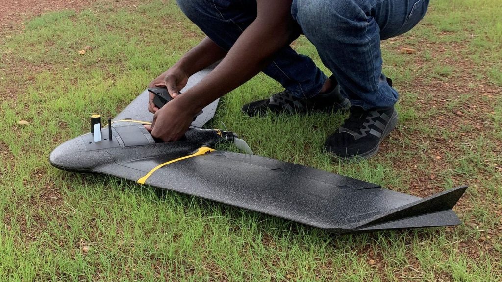
In Burkina Faso, in Africa’s Sahel region, a group of drone operators is making the surveying of land for irrigation and agriculture more accurate, quicker and cheaper.
More than 40 percent of the population Burkina Faso lives below the national poverty line and according to the World Bank, it faces degraded soils, chronic drought, flash floods, windstorms, and disease outbreaks from impacts of climate change.
Claudel Guiella, training coordinator at Burkina Faso Flying Labs explains that for these reasons, agriculture based on a water management system is crucial to the socio-economic development of communities there.
“In 2023, we sought to exploit drone technology in the agricultural development sector, by working with the Projet de Développement Agricole de Soum, which has developed an irrigation scheme covering more than 1,000 ha in the village of Soum, benefiting more than 5,000 rural households,” he says, adding that with conventional surveying techniques, engineers have to cover great distances, often dozens of miles on foot to survey points.
The drones, flying 360 feet above the ground, measured the physical or natural features of the land with under two inches of absolute accuracy, ending up with an accurate result, an 80% saving on the usual budget allocation and quicker delivery than conventional techniques.
“Drone surveys offer a better description of the terrain by producing more points (tens of millions) than conventional techniques (a few hundred for the same area), resulting in a more accurate canvas for civil engineering work,” Guiella says, adding that the implementation of technology could make this sector more attractive and more open to women.
He says that Burkina Faso’s development strategy has plans to develop over 30,000 hectares of irrigated land and his team hopes to consolidate what was learned in the pilot phase to scale up this drone-based solution.
Burkina Faso
Guiella grew up in Ouagadougou, the capital of the west African country of Burkina Faso.
After obtaining a degree in computer networks and telecommunications from the École supérieure des techniques avancées, he then worked as a computer systems and network administrator in a medium-sized industrial company before pursuing his passion for drones, artificial intelligent and geographic information systems.
“As a member of the Flying Labs Network, a global network of experts in drone technology and artificial intelligence, I deploy solutions to strengthen the resilience of communities in Burkina Faso in the face of the challenges of climate change and insecurity,” Guiella says, adding the pilot project shows how important it is for the Global South to develop its own capabilities.
“When people talk about drones and agriculture, they immediately refer to precision agriculture, but this system is not adapted to the current agricultural context in Burkina Faso,” he says, “Despite everything, this technology can still have a strong impact, if the beneficiaries are actively involved in the ideation process, facilitated by local expertise.”
Drones For Fighting Disease
Elsewhere in the Global South, Peruvian researcher Dr Gabriel Carrasco-Escobar, from the Institute of Tropical Medicine “Alexander von Humboldt” at the Universidad Peruana Cayetano Heredia (UPCH), is using drones and sensors to study the links between climate and diseases (like dengue, malaria, and leptospirosis) at the very local level, so that local authorities can make evidence-based policy decisions.
“A well-calibrated predictive model with sufficient spatial and temporal resolution can serve as an early-warning or rapid-response system and help mitigate the public health impact of these diseases,” Carrasco-Escobar says, adding that this work is a natural outgrowth of the ongoing HARMONIZE project, which was to build resilience against climate-susceptible infectious diseases in low- and middle-resource settings.
“One of the biggest challenges we have faced is the lack of earth observation data at the required spatial and temporal resolution; but to address this, we have deployed novel low-cost technologies in the Loreto region of Peru, including drones for high-resolution RGB, thermal and multispectral imaging, autonomous-recording acoustic sensors, weather stations, and air pollution sensors,” he says, “We now have protocols in place to standardize data collection and streamline data flows and will bsoon be integrating this data into a local predictive model for dengue.”
Read the full article here


